GEOlayers 3 V1.7.0 Script For After Effect
GEOlayers 3 v1.7.0 Script to Build Animated Map in After Effects
Now supports Helium for 3D landscapes. Design and animate maps directly in After Effects. Rebuilt from the ground up with tons of new features and faster and more powerful than ever!
In this section, you will see the GEOlayers 3 v1.7.0 script for Mac and Windows, which is suitable for creating animated maps directly in After Effects, and it is one of the best After Effects plugins for creating maps and animations with thousands of different tools.
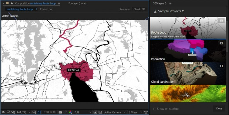
GEOlayers 3 lets you design and animate maps directly in After Effects.
It renders custom maps for you from different online data sources. It also provides direct access to extensive databases of geospatial features of the world. You can easily draw buildings to After Effects shape layers, highlight country borders, streets, lakes, rivers, places, regions, animate driving routes, and extrude buildings. Anything in the world that has geodata can be integrated as an editable asset in After Effects.
GEOlayers 3 comes with a large set of default map styles. But that’s not all. One-click lets you create a style from the colors of a composition, an image or Adobe Swatch file. You can also retrieve imagery from any common image-based tileserver. Platforms such as MapTiler Cloud can bring all its advantages of customizable basemaps directly into After Effects.
What’s new in GEOlayers 3
Version 3 is rebuilt from scratch. Since version 2, we’ve been collecting user input and improving the extension. GEOlayers 3 has been developed to fit your needs.
- New UI
- Maps can be pitched and rotated in 3D
- Automatic Labels
- Mapstyling directly in After Effects
- Faster Finalization
- Scripting API
In order to make all this possible, After Effects CC 2015 (13.6) or higher is required. Legacy projects created with GEOlayers version 1 or 2 are not supported by GEOlayers 3. You can still import old GEOlayers 2 server profiles, shape layer styles, and label templates.
Features
Animate in 3D Space
Intuitive controls to animate maps in 3D space
You can scroll, zoom, pitch, and rotate your maps inside After Effects, create keyframes and animate them. GEOlayers 3 renders all the imagery for your animation.learn more
Online Search
Find geographical features online
Search online for countries, cities, famous buildings, points of interest, and much more. The features you find can be labeled in your animation, they can be drawn to your map, downloaded, and even exported out for further analysis in an external GIS program.
Mapstyling
Style your maps however you want
You can style maps directly inside After Effects. Choose colors, adjust the line width, swap fonts, add hillshading to your maps and even show and hide certain groups of features. Note that for full control a MapTiler Cloud account is required.learn more
Labels
Add labels to your animation
Label features with one click. Use and customize the default label templates or feel free to create your own ones. Every After Effects composition can be used as a label template.learn more
Data Visualization
Create Data-driven shape layer styles.
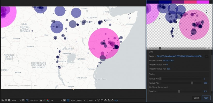
GEOlayers 3 allows you to easily import datasets in .csv or .tsv file format. Data-driven styling helps you to quickly visualize datasets in After Effects compositions with just a few clicks.learn more
3D Landscapes
Create 3D landscapes with one click
If you have Helium, Mettle FreeFormPro, Rowbyte Plexus or Trapcode Mir installed you can create gorgeous 3D landscapes setups in one click. You can achieve stunning animations based on real elevation data.learn more
User Guide Video Tutorials
MapTiler Cloud
An easy way to license mapdata for your video projects.
There is a very easy way to access and license mapdata for your commercial and non-commercial projects.
By buying a license for GEOlayers 3 you can check out OpenStreetMap-based data powered by MapTiler Cloud for two weeks. This empoweres GEOlayers 3 to style maps directly inside After Effects, automatically create mapcomp labels in different languages, and a lot more. After the two weeks you can of course use GEOlayers 3 without any additional cost. The data subscription is fully optional and can be purchased only as you need it.
What’s MapTiler Cloud for?
It empowers the following features of GEOlayers 3:
- A data license for your comercial projects
- High quality maps of the whole globe
- Style maps directly inside After Effects
- Find OpenStreetMap Features by clicking the preview map
- Mapcomp Labels in different languages
- Watermask Mapcomps
- Feature import for the current view
- 3D Building drawing
Apart from that you get:
- Access to the MapTiler Cloud platform
- Advanced map styling
- Additional datasets
- Upload your own datasets
- Use your maps on the web seamlessly
- and much more…


After effects templates
Amazing clips to use and help you create your own unique projects from AE templates or to improve the design of your existing broadcasts.
We have a wide range of templates for you to choose from. You can find PowerPoint Video Templates, Motion Graphics Templates, and After Effects Logo Templates, Scripts, Promos, news, fashion, sports, social media, titles…
After Effects Templates, Wedding Templates as well, After Effects Intro Templates, Transitions, Products Promos, Instagram stories, Scripts, Call Titles, Elements 3D, Corporate , and many more.
With After Effects project files, or templates, your work with motion graphics and visual effects will get a lot easier. In short, they are customizable After Effect files, neatly organized and labelled. You can easily change colors, text and other design elements without having to spend time on creating timelines and effects. It’s all there-you just need to customize it to fit your project.
What you waiting for? Hurry up and download the best after effects templates
➡️ ➡️ For more Ready Project Files Templates 😀 😀
➡️ ➡️ For more after effects plugins 😀 😀


Reviews
There are no reviews yet.